Information request: Disused bus pads on the 110 and 10

130101_0001

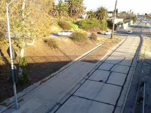
Bus pad at the Vermont Avenue exit of the northbound Hollywood Freeway

After writing about the idea of repurposing the 2 freeway as a tranistway, I’ve been thinking a lot again lately about buses and freeways, and specifically about bus pads: areas at a freeway interchange where there’s a lane for buses connecting the off-ramp to the opposite on-ramp. A bus stop is placed on this lane, along with, obviously, some means for pedestrians to access it from the surface street. The idea is to allow express buses to pick up and drop off passengers without getting slowed down by cross traffic the way they would if they exited the freeway outright. Now, bus pads have a lot of obvious drawbacks as a way of delivering rapid transit: buses running in mixed freeway traffic will be slowed down at rush hours; the area right around a freeway is likely to be comparatively lacking in nearby walkable destinations; the air quality won’t great for people waiting at the stop; and with certain interchange geometries, pedestrians may be forced into dangerous conflicts with traffic on ramps to reach the stop. Still, I’ve long been interested in the past and present of this particular form of transit infrastructure, which one might have imagined to be typical of a freeway-heavy place like Los Angeles.

As far as I know, there are seven active bus pads Los Angeles County:

I wanted to ask here about three other places where I’ve noticed what look like former bus pads, but which as far as I can tell are no longer in use:

  • On the 110 at 7th Street on the west side of Downtown Los Angeles. (Look for the stairs leading down from the street to the side of the freeway; in the Google Maps satellite image I’ve linked to, these are most visible on the north side of the street, going down to the southbound freeway lanes. This one is also a bit different because it’s just at an underpass, not at an actual exit.)
  • Two on the 10 at West Covina Parkway and Vincent Avenue. (If you look at the satellite images, you can see remains of sidewalks and crosswalks leading up to the slip ramp, and distinct pavement at what I take to be the place where the bus would have stopped.)

Does anyone have information about if or when these were most recently in use by buses? For the latter two, does anybody know if they’ll still exist after the I-10 HOV project is completed? Any information would be more than welcome via email at transiting dot la at gmail dot com. Thanks!

Footnote: Bus pads as defined above might be regarded as the middle of three taxonomic grades of freeway-based bus stops. The highest level are stops located along dedicated bus-only lanes or HOV/HOT lanes. In LA, the Rosecrans, Harbor Freeway/I-105, Manchester, Slauson, and 37th Street/USC stations on the Harbor Transitway, and the Union Station, LAC+USC Medical Center, and Cal State LA stops on the El Monte Busway fall into this category. Harbor Gateway Transit Center and El Monte might be described as terminal stations located at the end of such lanes.

At the next level down are bus pads. With these, buses have to operate in mixed traffic on the freeway, but their route is still fully grade-separated; they don’t have to leave the freeway to stop for passengers.

Below these are a category for which I’m not aware of there being an established term: the bus exits the freeway, crosses the intersecting surface street, and then re-enters the freeway at a directly-opposite entrance ramp, stopping for passengers near the end of the exit ramp or the start of the entrance ramp. In LA County, I know of examples of these on the 101 at Van Nuys Boulevard and Reseda Boulevard (northbound only); on La Cienega Boulevard at Slauson Avenue; and on the 10 at the Fairplex park-and-ride (westbound only). I think there at least used to be one on the 10 at Via Verde.

If anybody knows of further examples (past, present, or proposed) of any of these categories, I’d be happy to hear about those too!

Proposal: Replace the 2 freeway with a transitway and housing

After briefly taking this post down in response to feedback, I’m now putting it back up, with some more details about neighborhood campaigns related to the freeway terminus and previous suggestions to remove the 2 freeway stub south of the 5, both of which I should have given prominence to originally. I have not been able to find any mention of previous efforts to remove or repurpose the entire freeway (including the bulk of its length north of the 5) nor of efforts to repurpose the freeway specifically as a rapid transit corridor. If you have information about such efforts, I’d be very happy to find out where I can learn more and connect with people working on them. You can get in touch via email at transiting dot la at gmail dot com. Thanks!

Glendale_Freeway,_Glendale,_California_(14331254458)

What if this were a rapid transit corridor instead of an unfinished, underused, overbuilt freeway? (Photo: Ken Lund, distributed under CC BY-SA 2.0 license.)

Los Angeles may be the archetype of an American city cut through by a huge web of freeways, but many of the projects that were once planned were cancelled outright or completed only partially. The contentious gap in the 710 is probably the most famous example currently. One other freeway project, which was curtailed to a more radical extent, is the 2 (Glendale) freeway. Today, it runs in a northeast/southwest direction from Foothill Boulevard in La Cañada Flintridge to Glendale Boulevard in the Elysian Heights/Silver Lake area. Along the way, it was supposed to continue west as the Beverly Hills Freeway all the way to the 405. As I’ve mentioned on this blog before,  a physical remnant of this unbuilt extension exists in the form of the very wide median on the 101 where it passes under Vermont Avenue. This is where the 2/101 interchange was to have been. With the western portion of the 2 never built, it’s home today to grass, trees, and an unused bus pad, as seen in the photo below.

130101_0006

Wide median of the 101 freeway at Vermont Avenue, where the interchange with the 2 was to have been. The view is looking east; the disused bus pad is partially visible on the right, adjacent to the southbound lanes.

Because of its unfinished state, the 2 as we know it today is relatively under-utilized compared to the region’s other freeways. The way that the unfinished stub suddenly ends at Glendale Boulevard also has substantial traffic impacts on the surrounding area, which has given rise to long-running controversy between local residents and various concerned government agencies about how to reconfigure the terminus. The resulting State Route 2 Terminus Improvement project is based on a “hybrid” alternative which, I gather, few are all that happy with. I can’t hope to do full justice to the history of that debate here, but the Red Car Property blog, and the archives at Curbed, Streetsblog, and The Eastsider make good places to start if you want to read up on it.

Thinking more extensively, the idea has also popped up from time to time to outright remove the 2’s stub south of the 5. At a 2012 community workshop, a number of residents suggested replacing it with parks and housing, inspired by New York’s High Line. Christopher Hawthorne suggested similar ideas (also invoking the High Line) in the Times in 2015, which drew mixed reactions from readers. Just across the Los Angeles River from the 5 and the stub, Let’s Go LA suggested in 2015 that 2’s exit ramps at Fletcher Drive could be removed both to improve traffic flow on the freeway by spacing out exits better, and to free up the land for new housing.

As LA grapples with issues relating to the health hazards of living near freeways, Alissa Walker has recently floated the idea of dismantling them altogether. In that spirit, I’d like to explore an even more extensive possibility for the 2: removing not just the stub, but the entire freeway, using a portion of its right-of-way as a readymade, grade-separated rapid transit corridor (for buses and/or rail), and using the remaining land freed up by removing the freeway’s lanes and ramps (plus associated buffer zones) to build new transit-oriented housing and parks.

Continue reading

Map of Transit Connections and Gaps Across California

This post (originally from 3/6/18) is updated occasionally, but certainly not comprehensively. Because a lot of the material covered is still in flux due to COVID, and because I’ve been busy with other things, I’ve largely stepped back from actively updating the map for the time being, but I do still update the post now and then.

The most recent version of the map (v. 1.3.9, 6/13/20) can be found here. Summaries of the past updates to the map can be found here and here.

map-preview-2.23.20

See below for link to full map.

Most recent version of the map (v. 1.3.9, 6/13/20)

When I first started this blog, I had a post about how to make an epic trip across California using connections between different transit agencies. As I learned more about that topic, it quickly became apparent that there were a number of different combinations of routes by which you could make such journeys. To help myself organize that information, I decided to start making a map. I started out just wanting to get a handle on all of the possible routings between LA and San Francisco, but eventually the map grew to cover the whole state as well as connecting transit services in neighboring states. After a couple of years of on-and-off work, this resulted in something I decided was finished enough to publicly share.  You can download a pdf of the map here.

I should note up front that I am not by any stretch of the imagination a graphic designer. I created the map using Inkscape, which I (incompletely) taught myself in the course of working on this. Be prepared for aesthetic deficiencies and possible technical issues. Despite my best efforts, there are undoubtedly substantive errors and omissions too. Feedback (to transiting.la [at] gmail.com) would be most welcome!

In the course of creating the map, I read and learned a lot not only about what transit services existed around the state and connected with each other, but also about where connections didn’t exist. So in addition to the map, I also began to compile a list of significant gaps around the state where it seemed to me like it would be reasonable and desirable to introduce connections between neighboring transit agencies.

I also learned a good deal about services in the Pacific Northwest that don’t quite have connections to statewide transit network in California. As it turns out, except for a couple of places in Oregon, there is a continuous web of interconnected transit agencies stretching all the way from Baja California to Alaska. But up and down the West Coast, there are also quite a few gaps between the networks of nearby agencies which would, arguably, make a lot of sense to bridge. Curious? Read on!

Continue reading

Bus stations on the Hollywood Freeway

A few months back I wrote about the idea of extending the Metro Silver Line south to serve the stations at the Carson Street and Pacific Coast Highway
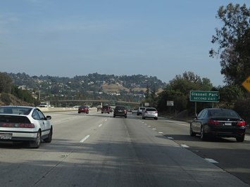
 exits on the 110 freeway. I’ve been thinking a lot lately about this kind of freeway-based bus facility. Unlike the Silver Line’s stops on the Harbor Transitway proper, which are in the median of the roadway between the traffic lanes, these two stations are located at diamond-interchange exits. For illustration, here’s the Carson station:

The bus facility is most visible on the left, on the southbound side of the freeway. Marked on the map with Google’s yellow road-lines are the exit and entrance ramps. If you look closely, you can see that there’s an additional southbound bus-only lane, parallel to the main freeway, connecting the exit and entrance ramps. The bus stop is along this bit of roadway. The bus, traveling in mixed traffic on the freeway, exits at the ramp, enters the lane serving the bus stop, and then after stopping to pick up and discharge passengers, merges onto the entrance ramp and then back onto the freeway proper. Continue reading

Transit History: The Downtown People Mover

Perhaps more than in any other American city, in Los Angeles discussion of public transportation’s future takes place in the shadow of its past. The memory of the Pacific Electric Railway, and of its abandonment, looms large (often to mythological proportions) in debates about transit in Southern California. But of course, there’s far more than Red Cars to Southland transit history, and these other elements of our past provide interesting insights into varied and changing conceptions of the aims of a public transportation system, of who it should serve, and of how it fits into overall goals for the future of the city; provide examples (positive and negative) of how and where future transit projects could be built; and sometimes even leave behind physical traces to be explored, and maybe even to be re-used for transit again in the future. So one of the things I want to do with this blog is to look at the past of public transit in LA, including at past proposals which were never realized. Continue reading